
Restoring the Au Sable at Twin Bridge Road
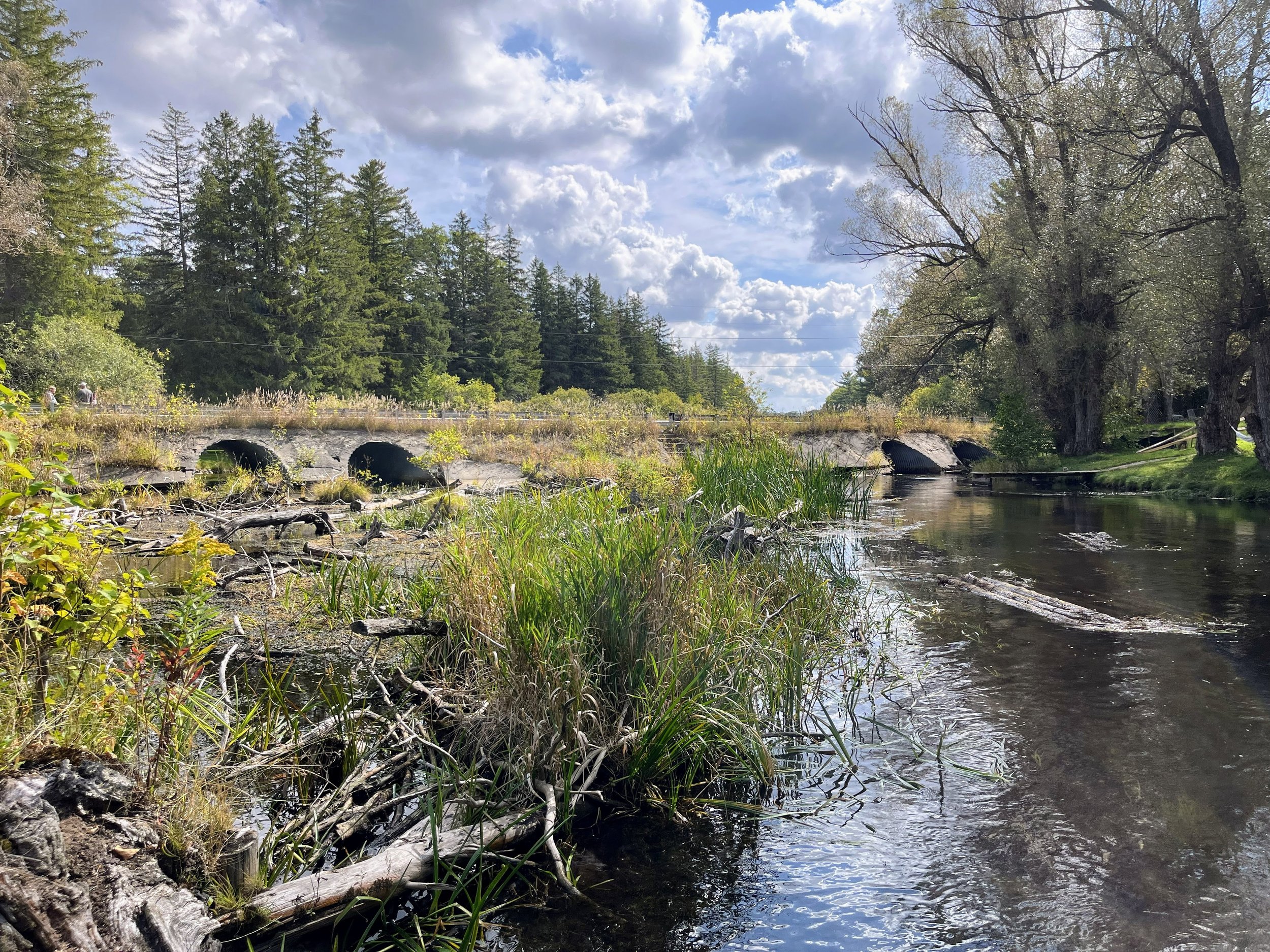
Huron Pines is preparing to restore the Twin Bridge Road crossing of the North Branch Au Sable River in 2027. Two pairs of culverts at this site are severely undersized for the river, causing longstanding issues with erosion and restricting fish passage to upstream habitat.
Working with the Crawford County Road Commission, engineering firm OHM Advisors and a qualified contractor, Huron Pines will replace the culverts with two new concrete bridges, restoring natural river function along this prized tributary of the Au Sable River.
Project Background
Undersized road/stream crossings have negative impacts on river processes and aquatic wildlife and can pose road safety and maintenance concerns. Well-connected rivers allow fish to move to upstream habitat for spawning, foraging, and to seek refuge from environmental stressors. Appropriately sized and aligned road/stream crossing structures are designed to restore stream channel geometry, substrate, and flow conditions that match the natural character of the river reach as if the road wasn’t there. Conversely, undersized culverts constrict and speed up river flow which can block or impair upstream fish passage, disrupt transport of sediment and woody debris, drive up risks of flood-related damage including erosion and potential road washouts, and can impact the recreational use of such sites (e.g., limit passage beneath the road by wading anglers and paddlers).
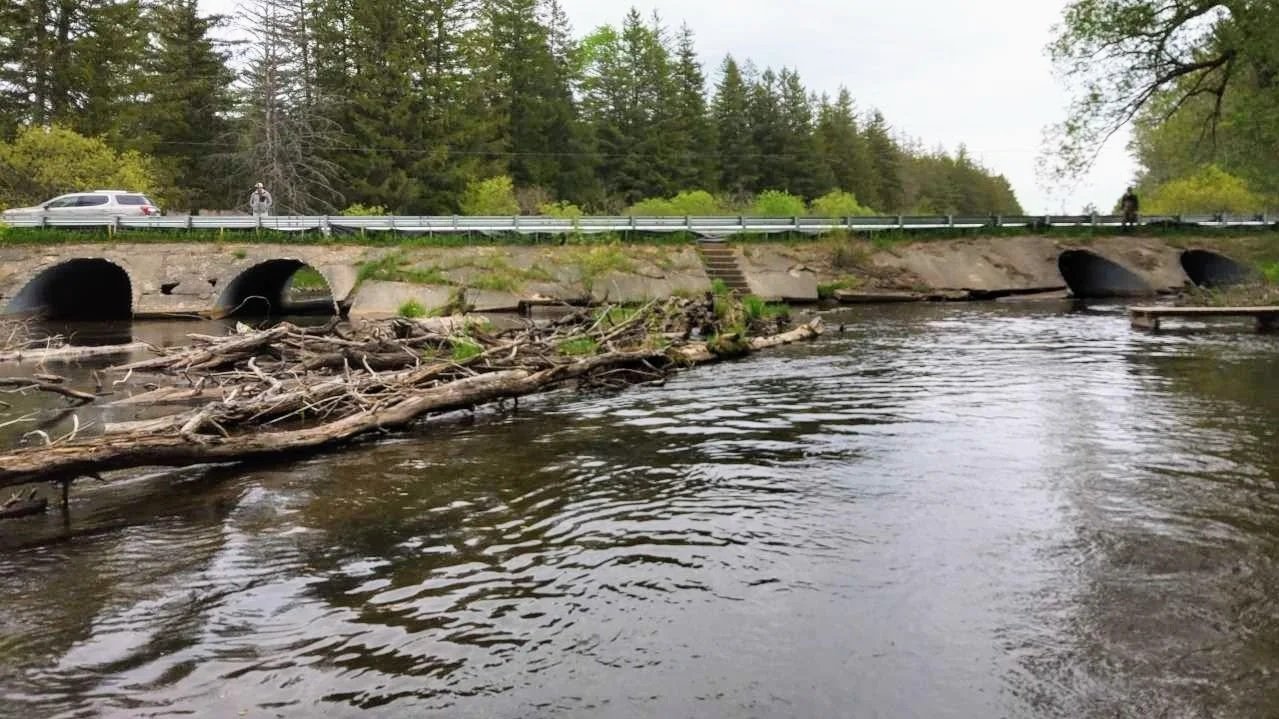
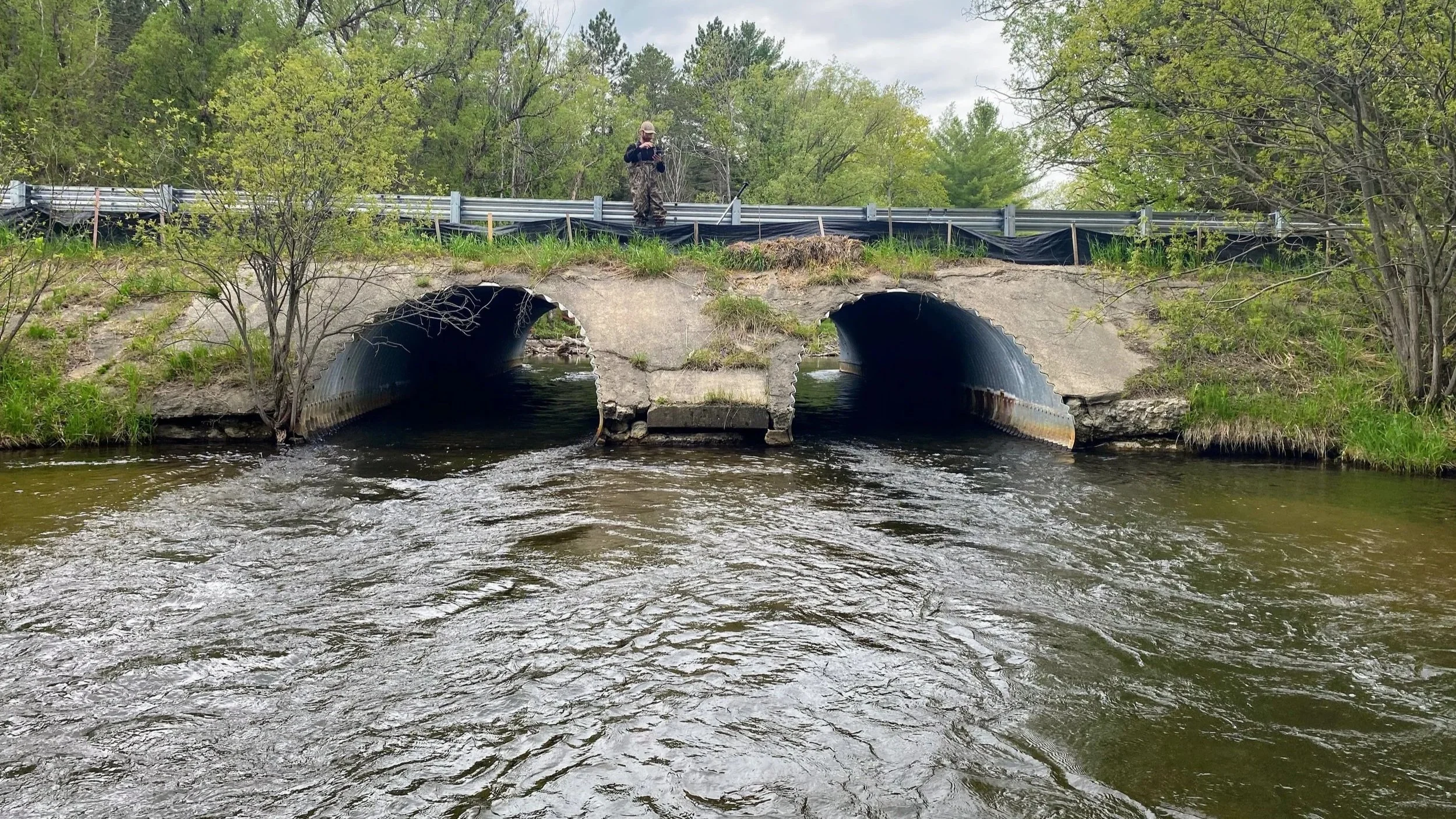
The four culverts at the Twin Bridge Road/North Branch Au Sable River (pictured above in May 2022) are severely undersized. Each of the existing culverts is 53.5 feet long, with a span of 10 feet and height of 7 feet. The stream width immediately upstream and downstream is approximately 100 feet, meaning the 40 feet of total span of the four existing culverts accommodates only 40 percent of the natural stream width. This forces water through the culverts at velocities that are higher than normal*. Partners have shared that telemetry evidence exists demonstrating adult brown trout can pass through the culverts; however, these flow velocities are likely to block or impair the upstream passage of younger trout and other native fishes that tend to be weaker swimmers.
*Flow velocities of 5.2 feet per second, 5.9 fps, 5.6 fps and 3.6 fps were recorded with a digital flow probe at the culvert outlets (left to right when facing downstream) at Twin Bridge Road on May 25, 2022 per the Great Lakes Road/Stream Crossing Inventory Protocol.
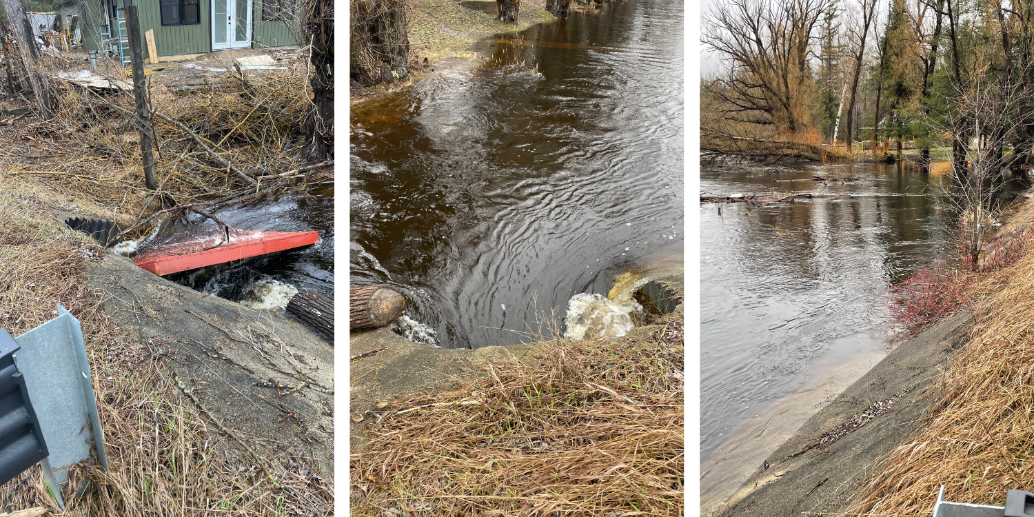
The undersized culverts and their poor alignment alter channel geometry, sediment transport, the movement of wood through the river system, contribute to scour and erosion, and put this crossing at risk of washout during flood events such as those which occurred in April 2026 (pictured below). The extensive concrete headwall is cracked and crumbling, with holes present that allow river water to enter the space between culverts. This is a serious concern for road integrity because it could cause seepage, loss of road fill, formation of sinkholes in the road core, and potentially the catastrophic collapse of the road surface, or washout of the roadway and crossing structure. Recent extreme flood events have washed out many culverts in the region in recent years and the Twin Bridge Road site will remain at risk of washout until these culverts are replaced.
Huron Pines is working with the Crawford County Road Commission, which owns and manages the Twin Bridge Road/North Branch Au Sable River crossing, OHM Advisors (engineering firm) and a qualified construction contractor (to be selected through a competitive bid process) to replace the four undersized culverts with two new concrete bridges, each with a span of 72.38 feet, resulting in a total span of 144.76 feet over the north and south channels. All required permits have been thoroughly reviewed and approved by the appropriate state agencies, and federal compliance approvals have been completed. Designs and mitigation methods have been deemed safe and appropriate for the river and construction is planned for spring through fall of 2027.
Why This Site Was Selected for Restoration
Huron Pines has successfully managed more than 140 road/stream crossing improvement and dam removal projects across Northern Michigan, reconnecting more than 700 upstream miles of river for fish passage in the last two decades. We identify potential projects for restoration through comprehensive inventories of road/stream crossings across northeast Michigan and prioritize sites based on factors including fish passage, flood risk and erosion issues, quantity and quality of upstream miles a project would reconnect, status as coldwater trout streams, presence of rare species and habitats, recreational benefits, and availability of funding and in-kind project support.
For many years, Huron Pines, the Crawford County Road Commission, Michigan Department of Natural Resources (DNR) and others have considered the Twin Bridge Road crossing of the North Branch Au Sable River (inventory site ID: CR081) a priority for restoration but, due to the size and complexity of this site which requires the construction of two large bridges over two river channels at this crossing, funding has remained the main obstacle for this project.
At Twin Bridge Road/North Branch Au Sable River, the existing culverts are severely undersized for the width of the river at this location, and the crumbling concrete headwall creates safety concerns and negatively impacts river health, fishery resources, road integrity and recreation use. The site impairs upstream fish passage to more than 20 upstream miles on a recreationally valued, high-quality coldwater trout stream. The site was prioritized for restoration based on the degrading condition of its existing infrastructure, risks related to erosion and potential washout in future flood events, fish passage and recreation concerns, and negative alteration of natural river form and function due to the severely undersized culverts.
What Full Site Restoration Will Achieve
This restoration project will replace aging and deteriorating infrastructure with new, appropriately sized concrete bridges that will improve safety and road integrity while minimizing the risk of road washout at flood stage. Each bridge will have a 72.38-foot span compared to the four, 10-foot-wide culverts currently present at the site.
The project will enhance upstream fish passage to 20.4 upstream miles (calculated using the Great Lakes Fishery Commission’s Barrier Tracing Tool, accounting for other upstream barriers in the watershed). Stream conditions under the roadway will mimic natural conditions of the North Branch Au Sable River to provide year-round passage for fish of all age classes and species, along with improved passage for other aquatic wildlife and recreationists who wade or paddle this stretch of river. The project will restore channel geometry, hydrology, sediment transport, movement of wood and nutrients, and other river functions to a more natural condition that better matches the upstream and downstream reaches of the North Branch Au Sable River. View the project area below:
The Twin Bridge crossing is an unofficial recreation access point to the North Branch Au Sable River and similar access will be maintained, with the exception of existing stairways at the center of the crossing which will be removed due to safety and design constraints of the new bridges. Anglers and paddlers will find it much easier to pass beneath Twin Bridge Road thanks to wider, higher and slower flow conditions within the crossing which further improves safety at the site. The DNR-managed public access at Sheep Ranch, a half-mile upstream from Twin Bridge Road, is a great alternative location to access this reach of the North Branch Au Sable River. Improvements to the Sheep Ranch access site are planned or in progress by other parties.
Project Partners & Funders
Funding for the project is from the United States Environmental Protection Agency’s Great Lakes Restoration Initiative, with the completed design and permitting phase administered by the DNR Fisheries Division and the construction phase being administered by the Michigan Department of Environment, Great Lakes, and Energy. Huron Pines is the project manager and is coordinating the project partners.
Project partners and roles are as follows:
Huron Pines, project manager
Crawford County Road Commission, road owner and permittee
OHM Advisors, engineer for design and construction phases
qualified construction contractor, to be determined for construction and restoration phases
Michigan DNR, DNR Natural Rivers permit holder, technical guidance, EPA funding administration
Michigan EGLE, joint EGLE/USACE permit holder, technical guidance and EPA funding administration
Adjacent landowners, providing temporary grading easement
Public stakeholders, providing feedback on designs, working through sediment concerns
Project Timeline
Design Phase, completed 2024-2025:
US EPA funding is secured and administered by Michigan DNR
Huron Pines contracts with the Crawford County Road Commission, which hires engineering firm OHM Advisors to develop designs and apply for project permits
Stakeholders and adjacent landowners meet on multiple occasions to discuss options for project designs (May 23, 2024; Sept. 19, 2024; March 11, 2025; May 16, 2025)
Designs for new concrete bridges are developed, including installation of tree revetments to help lock in an existing sediment island on the upstream side of the crossing in response to stakeholder concerns about sediment
A Michigan EGLE permit is secured for the bridges and tree revetments
Partners consult with the U.S. Fish & Wildlife Service’s Sea Lamprey Control Program which grants approval of the project
Federal compliance consultations are completed and clearance is received from the National Environmental Policy Act (NEPA) Section 7, Endangered Species Act, Michigan State Historical Preservation Office and National Historic Preservation Act Section 106, and Tribal partners
Construction Phase:
US EPA funding for construction is secured in 2025 and administered by EGLE
Huron Pines hires OHM Advisors as project engineer
Partners and stakeholders meet again on site May 12, 2026
Project update document is distributed to partners and stakeholders Aug. 3, 2026
Huron Pines works with engineer and DNR Fisheries Division to quantify sediment loads, including those expected to mobilize during the project, as well as baseline expected annual sediment loads for the North Branch Au Sable River at Twin Bridge Road based on contributing drainage area, in Summer 2026
DNR Natural Rivers permit is reapplied for and granted in Summer 2026
Huron Pines consults with road commission, project engineer, adjacent landowners and utility companies on temporary grading easements and utility line relocation as necessary, in progress
Construction contractor bids advertised in Fall 2026
Contractor bids are evaluated and a qualified contractor is selected, pending sufficient funds, in 2026
Construction occurs in 2027, with on-site activity anticipated for most of Summer and Fall 2027
Final site restoration, formal inspection, corrective work if applicable, and paving occurs in Fall 2027
Post-project monitoring proceeds in 2027 and beyond as funding allows
Managing Sediment During Construction & Beyond
The qualified contractor selected for the project will be required by contract to implement soil erosion and sediment control measures that minimize the input of sediment related to construction, and are required to comply with conditions of the Michigan EGLE permit.
By their design, the new bridge structures will reduce the input of new sediment at the road crossing by improving stormwater runoff, eliminating streambank erosion caused by the existing culverts, and by avoiding the substantial input of sediment and road fill that would result from failure and washout of the existing culverts.
Huron Pines, OHM Advisors, and EGLE and DNR Fisheries Division staff have met on-site with stakeholders to discuss sediment management concerns. Some stakeholders requested that we 1) take measures to stabilize the upstream sediment island; 2) conduct a study to quantify the sediment load; and 3) remove sand from the river channel upstream from the crossing prior to bridge construction using hydraulic pumping or similar methods.
In response to those requests, the project team incorporated into project designs the installation of tree revetments along both sides of the upstream sediment island, a feature which goes above and beyond what is typically required for a road/stream crossing restoration project. Huron Pines also worked with OHM Advisors and the DNR Fisheries Division to collect longitudinal survey data of the river to quantify sediment estimates to help inform decisions. Based on the relatively small volume of sediment expected to mobilize from the upstream reach as a result of the project, compared to the estimated annual sediment load passing through this location naturally, Huron Pines intends to move ahead with the project as permitted.
Others may wish to pursue the removal of sand from the upstream river channel via hydraulic pumping or other methods at their own discretion but would be responsible for securing funding, additional permitting and landowner authorizations, and the implementation of such additional work.
Calculating Sediment Mobilization
A field survey by OHM Advisors calculated stream slope at the project site as 0.001 feet/foot. An elevation drop of the streambed, from the existing culvert floors to the natural streambed conditions under the new bridge structures, is expected to be 0.45 feet.
Based on these calculations, the headcut will extend 450 feet upstream from the crossing before meeting the existing streambed elevation. The average channel width through this reach is approximately 76 feet. Therefore, we can calculate the volume of the predicted headcut and the volume of sediment expected to move as a result of the project at less than 300 cubic yards.
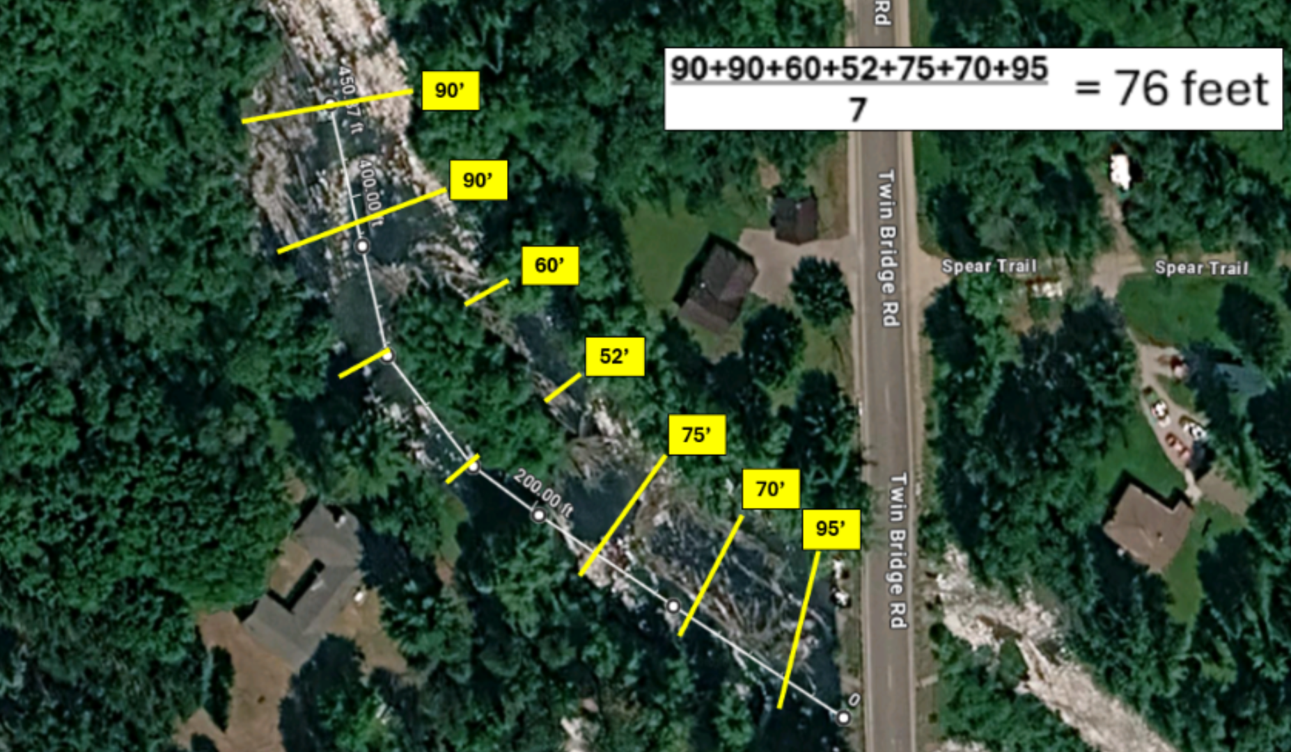
To put this in perspective, Huron Pines worked with DNR Fisheries Division staff to estimate the annual sediment load moving naturally through the North Branch Au Sable River at Twin Bridge Road, based on the contributing drainage area of 104 square miles. Using the Creech Curve method, this provides an estimated annual sediment load of 10,807 cubic yards. If we conservatively assume the Au Sable River Watershed has a natural sediment load that is approximately 25% lower than other similarly sized river systems, the baseline sediment load at Twin Bridge Road may be closer to 7,500 cubic yards.
Therefore, expected sediment mobilization as a result of construction represents a small faction of what moves naturally through this crossing annually, and a one-time sediment mobilization equal to 2 to 4 percent of baseline annual load. On average, a sediment volume of approximately 300 cubic yards moves naturally through the Twin Bridge Road site every 10 to 15 days.
Due to restricted river flows at Twin Bridge Road, sand and sediments which would otherwise move naturally through the river system become temporarily trapped upstream of the crossing. Flood events periodically flush some of this deposited material through the reach and, during base flow conditions, it can start to build up again. Replacing the existing culverts with appropriately sized bridges will restore natural flow conditions and sediment transport through the project stream reach in a way that closely mimics sediment transport in natural reaches of the North Branch Au Sable River away from road crossings.
With this comparatively small amount of sediment expected to mobilize during construction, and with further mitigation by tree revetments at the sediment island upstream, Huron Pines and permitting agencies are comfortable moving ahead with the project as designed.